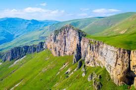
In the last decade, Armenia has quietly pulled off one of the most successful tourism rebrands in the Caucasus. Once known primarily for its ancient monasteries and cognac, the country has leveraged its greatest natural asset—its jagged, vertical topography—to position itself as a world-class trekking destination.
This is not just a story about hiking; it is a case study in how open-source infrastructure (trails), NGO-led development, and local entrepreneurship can converge to revitalize rural economies.
I. The Landscape: Why Armenia?
To understand the business of trekking here, you must understand the product. Armenia is 90% mountainous, but its terrain is distinct from the neighboring Greater Caucasus in Georgia.
- Georgia offers massive, snowy, Alpine-style peaks (5,000m+).
- Armenia offers volcanic plateaus, dramatic canyons, and "high desert" landscapes that feel more like Mars than Switzerland.
This distinction is crucial. It means Armenia attracts a specific type of trekker: one looking for remoteness, ancient history on the trail (Silk Road bridges, cliffside chapels), and technical accessibility without the need for ropes and crampons (mostly).
II. The Infrastructure Revolution: The Platform Model
The trekking boom didn't happen by accident. It was engineered by two major entities that function less like tour operators and more like "platforms" for the industry.
1. The Transcaucasian Trail (TCT). The TCT is the "hardware" of the industry. The vision is a 3,000km continuous route connecting Georgia, Armenia, and Azerbaijan. The Armenian section is arguably the most developed—you can now thru-hike from the Georgian border in the north down to the Iranian border in the south (approx. 860km). The TCT brought international marking standards (red/white blazes) to Armenia. Before this, hiking here required local knowledge or a Soviet military map. Now, it is an accessible product for the solo European backpacker.
2. HIKEArmenia. If TCT is the hardware, HIKEArmenia is the "software" (and the OS). Funded initially by the Hovnanian Foundation, HIKEArmenia operates as a non-profit—they don't sell tours to make a profit, they build the ecosystem. They created a free app that serves as the "Google Maps" of Armenian trails, and their office in Yerevan acts as a dispatch center, connecting tourists with freelance guides and rural B&Bs. This lowers the barrier to entry for local guides who don't have the marketing budget to find clients on their own.
III. The Market: Key Players & Segmentation
The business ecosystem has matured into three distinct tiers.
Tier 1: The Local Giants (Operator Level) — these companies dominate the market and control the logistics. Armenian Geographic (ArmGeo), the market leader, started as a group of geographers and explorers, which gives their brand high credibility; they run the "mass market" weekend hikes for locals (50–100 people) and high-margin private expeditions for tourists. ArmLand is the "hardcore" option, focused on mountaineering (Mt. Ararat, Mt. Kazbek, Mt. Aragats), capturing the segment of tourists who want to "conquer" peaks rather than just walk.
Tier 2: The Experience Architects (Luxury/Niche) — a newer wave of operators focusing on high-spending tourists who want comfort. We Hike Armenia / ONE Way Tour have realized that Western tourists often want a "soft adventure"—hike for four hours, then have a wine tasting and sleep in a boutique hotel. OnlyLuxe and other international operators now white-label Armenian treks, selling them for premium prices ($3,000+ per trip) to Australian and American markets.
Tier 3: The Rural Micro-Economy — this is where the real economic development is happening. The trails have birthed a network of "Gastro-Yards" and B&Bs in villages that previously saw zero tourism. Case study: the village of Gomk in Vayots Dzor, situated on the TCT route, was largely bypassed until the trail put it on the map. Now, local families offer homestays to thru-hikers, creating a direct cash injection into the village economy.
IV. Strategic Regions for the Trekker
| Region | Best for | Character |
|---|---|---|
| Dilijan National Park | Families & beginners | Lush forests, humidity, medieval monasteries — the "easier" hiking hub with the best hotel infrastructure. |
| Geghama Mountains | Adventure seekers | High-altitude volcanic trekking. No villages, just nomads (Yezidis) and dragon stones. You must camp. |
| Vayots Dzor | History buffs | Red rocks, canyons, and the Noravank monastery. High exposure to sun, dramatic views. |
| Syunik (Tatev) | Deep exploration | The "Wild South" — rugged gorges, deserted villages, and part of the "Legends Trail." |
V. Challenges & Future Outlook
Despite the boom, the industry faces bottlenecks. Seasonality is a constraint: high-altitude trekking (Geghama/Aragats) is only viable from July to September, and the "shoulder season" business (May/Oct) is growing but limited to lower altitudes (Dilijan/Lori). Search and rescue capacity is another gap—Armenia still lacks a centralized, helicopter-based mountain rescue service comparable to the Alps; rescue is currently a mix of Ministry of Emergency Situations and volunteer efforts. And overtourism risk is emerging: popular trails (like the route to Dimats Mt in Dilijan) are beginning to see erosion and overcrowding on weekends, prompting calls for better trail management.
More reading: kandooadventures.com — Trekking in Armenia